faial island - azores
The 1998 Azores earthquake remains as one of the most recent evidence of loss and damage derived by seismic activity in Portugal. This event raised again the awareness and attention to seismic risk and the associated vulnerability of our building stock and built heritage. Since back then several studies were developed based on post-earthquake damage observation, which stills a precious data to validate and calibrate methodologies, once researchers are allowed to compare their models and methods with real damage. Similar to other countries, but in a minor scale, the huge amount of generated processes of traditional masonry damaged buildings deeply surveyed, and the respective extension and inventorying of both global and local damage has originated important breakthroughs on Portugal's scientific community, particularly on the seismology and earthquake engineering fields. Hence, before embracing the fieldwork, we have concentrated efforts on gathering and organising diffused data held by some of the most experienced members of our team, who have directly contributed and cooperated in field at the time of the 1998 earthquake, namely professors Carlos S. Oliveira and Aníbal Costa.
One of the goals regarding the URBSIS project concerns calibrating and validating the vulnerability index large-scale assessment methodology, which is based on in situ survey and inspection of buildings, by attributing an index value to each building through the evaluation of several parameters related to intrinsic characteristics and some geometrical and mechanical properties of traditional stone masonry buildings.
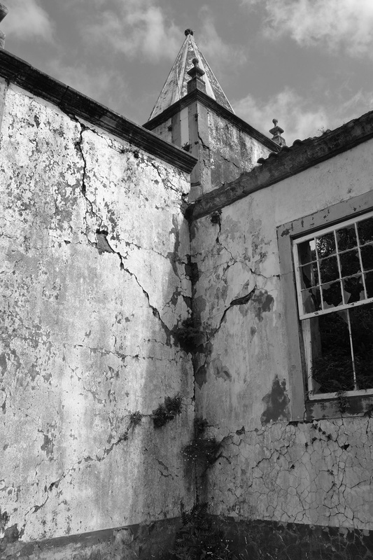
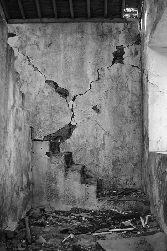
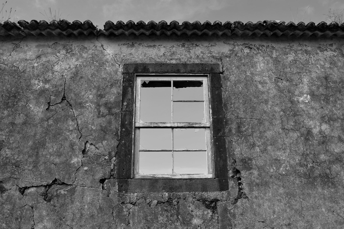
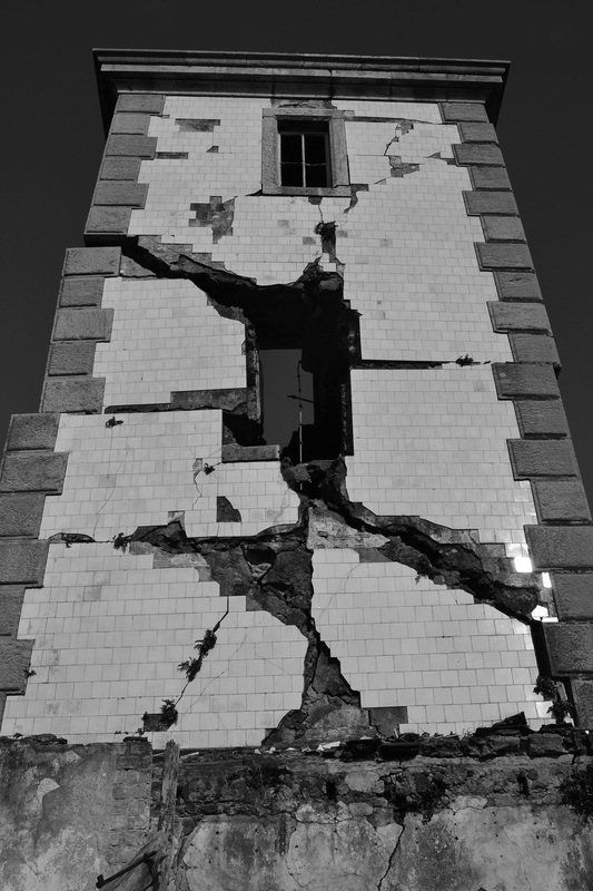
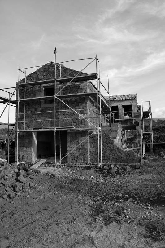
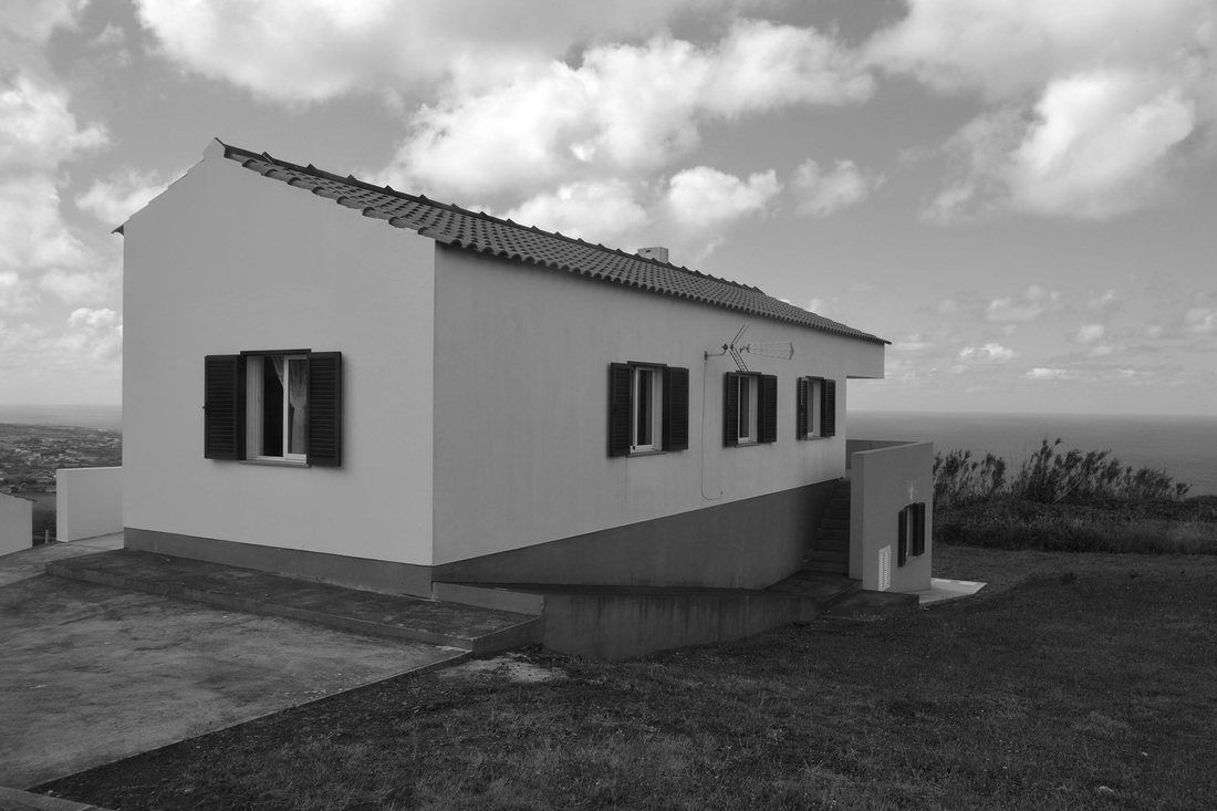
In this sense, our team members Romeu Vicente, Tiago Ferreira and Rui Maio, have spent a few days in June working in the field to bring out detailed and useful information to complete our database. During this period we've been focused on researching in three main different fronts: collecting useful and valuable information from the available Municipal archives (SPRIH e Reg); surveying and mapping urban buildings belonging to Matriz parish and surveying unchanged damaged buildings located in rural areas spread all over the island of Faial. As one can see from the following pictures, it is still particularly staggering for us to face some of the attained buildings exactly as they are 16 years after the event.
the July 9th, 1998 Azores earthquake and the reconstruction process
"It was exactly 5.19 am o'clock when a sledgehammer, 19 seconds long earthquake of magnitude equal to 5.8 in the Richter scale attained the Islands of Faial, Pico and S. Jorge, of the Azores Archipelago, causing a total of 8 deaths and 100 injured people. This earthquake destroyed about 70% and 20% of the building stock of Faial and Pico Islands, respectively, as well as several infrastructures and community/public facilities, including roads, bridges, aqueducts, retaining and property delimiting walls, churches, cemeteries, schools and cultural and sports bodies, which have strongly undermined our collective memory. Thus, in a short period of time, countless immediate measures and decisions were taken according to the established priorities of fixing communications, clear passages, port equipments damage inspection, airport, road transport, educational, sanitary, social and general support services and relocating homeless population." by Fernando Nascimento, Chair of Management Board of SPRIH [1].
"The Azores Archipelago located at the triple junction of the Eurasian, North American and Nubian plates is the most important seismic region of Portugal (with higher seismicity), even not uniformly spatially distributed, either in terms of magnitude or frequency of earthquakes, all over the islands. The great majority of earthquakes generated on the islands and nearby seas active faults (e.g. Azores Plateau) have magnitude under 6.0 and only just a few of moderate to strong quakes that are generated on the Azores-Gilbraltar Fault od affect the islands (e.g. November 1st, 1775 and May 26th, 1975).
The "Seismic Catalogue of the Azores Region" and the "Azores Seismic Database" allow us to analyse and characterise the seismicity of the Azores during almost six centuries and are important tools on seismic hazard studies, namely for the seismic scenario approaches. In general terms, four main seismotectonic systems can be defined: i) the islands of São Miguel, Terceira and Faial (with higher seismicity, frequent felt earthquakes); ii) the islands of Pico and São Jorge; iii) the islands of Graciosa and Santa Maria and iv) the islands of Flores and Corvo, on the North American plate and with reduced seismicity." by João Carlos Nunes from University of Azores [2]
references
fail island | 16 years after the earthquake in pictures
The 1998 Azores earthquake remains as one of the most recent evidence of loss and damage derived by seismic activity in Portugal. This event raised again the awareness and attention to seismic risk and the associated vulnerability of our building stock and built heritage. Since back then several studies were developed based on post-earthquake damage observation, which stills a precious data to validate and calibrate methodologies, once researchers are allowed to compare their models and methods with real damage. Similar to other countries, but in a minor scale, the huge amount of generated processes of traditional masonry damaged buildings deeply surveyed, and the respective extension and inventorying of both global and local damage has originated important breakthroughs on Portugal's scientific community, particularly on the seismology and earthquake engineering fields. Hence, before embracing the fieldwork, we have concentrated efforts on gathering and organising diffused data held by some of the most experienced members of our team, who have directly contributed and cooperated in field at the time of the 1998 earthquake, namely professors Carlos S. Oliveira and Aníbal Costa.
One of the goals regarding the URBSIS project concerns calibrating and validating the vulnerability index large-scale assessment methodology, which is based on in situ survey and inspection of buildings, by attributing an index value to each building through the evaluation of several parameters related to intrinsic characteristics and some geometrical and mechanical properties of traditional stone masonry buildings.
In this sense, our team members Romeu Vicente, Tiago Ferreira and Rui Maio, have spent a few days in June working in the field to bring out detailed and useful information to complete our database. During this period we've been focused on researching in three main different fronts: collecting useful and valuable information from the available Municipal archives (SPRIH e Reg); surveying and mapping urban buildings belonging to Matriz parish and surveying unchanged damaged buildings located in rural areas spread all over the island of Faial. As one can see from the following pictures, it is still particularly staggering for us to face some of the attained buildings exactly as they are 16 years after the event.
the July 9th, 1998 Azores earthquake and the reconstruction process
"It was exactly 5.19 am o'clock when a sledgehammer, 19 seconds long earthquake of magnitude equal to 5.8 in the Richter scale attained the Islands of Faial, Pico and S. Jorge, of the Azores Archipelago, causing a total of 8 deaths and 100 injured people. This earthquake destroyed about 70% and 20% of the building stock of Faial and Pico Islands, respectively, as well as several infrastructures and community/public facilities, including roads, bridges, aqueducts, retaining and property delimiting walls, churches, cemeteries, schools and cultural and sports bodies, which have strongly undermined our collective memory. Thus, in a short period of time, countless immediate measures and decisions were taken according to the established priorities of fixing communications, clear passages, port equipments damage inspection, airport, road transport, educational, sanitary, social and general support services and relocating homeless population." by Fernando Nascimento, Chair of Management Board of SPRIH [1].
"The Azores Archipelago located at the triple junction of the Eurasian, North American and Nubian plates is the most important seismic region of Portugal (with higher seismicity), even not uniformly spatially distributed, either in terms of magnitude or frequency of earthquakes, all over the islands. The great majority of earthquakes generated on the islands and nearby seas active faults (e.g. Azores Plateau) have magnitude under 6.0 and only just a few of moderate to strong quakes that are generated on the Azores-Gilbraltar Fault od affect the islands (e.g. November 1st, 1775 and May 26th, 1975).
The "Seismic Catalogue of the Azores Region" and the "Azores Seismic Database" allow us to analyse and characterise the seismicity of the Azores during almost six centuries and are important tools on seismic hazard studies, namely for the seismic scenario approaches. In general terms, four main seismotectonic systems can be defined: i) the islands of São Miguel, Terceira and Faial (with higher seismicity, frequent felt earthquakes); ii) the islands of Pico and São Jorge; iii) the islands of Graciosa and Santa Maria and iv) the islands of Flores and Corvo, on the North American plate and with reduced seismicity." by João Carlos Nunes from University of Azores [2]
references
- O Sismo de 9 de Julho de 1998 e a reconstrução. In book Sismo de 1998 - Açores - Uma década depois. Editors: Carlos S. Oliveira; Aníbal Costa and João C. Nunes. 1st Edition July 1998, ISBN: 978-989-20-1223-0 (in Portuguese).
- Nunes, J.C. Caracterização sumária da sismicidade da Região dos Açores. In Chapter 03, Parte I - Caracterização do Sismo, Contexto Histórico, Geologia e Geofísica, of Sismo de 1998 - Açores - Uma década depois. Editors: Carlos S. Oliveira; Aníbal Costa and João C. Nunes. 1st Edition July 1998, ISBN: 978-989-20-1223-0 (in Portuguese).
fail island | 16 years after the earthquake in pictures