faro's ribeirinha historical area
seismic vulnerability assessment at urban scale
In the last decades the evaluation of the seismic risk is of rising concern, considered essential in the activity and definition of strategy planning and urban management. The evaluation of the seismic vulnerability of the existent building stock in the perspective of seismic risk mitigation should not be placed only in relation to the isolated buildings of relevant historical and cultural importance, but also, in relation to residential buildings within old urban centres. When assessing the seismic vulnerability of buildings it is essential to first establish the project objectives, before subsequently choosing the most appropriate strategy and tools necessary for building assessment and fulfilment of these objectives. It is also extremely important to understand the difference between the detailed approaches used for individual building assessment and those methods most efficient for larger scale analysis, pursued for city centre assessment.. The results attained from the vulnerability assessment of the Faro's ribeirinha old city centre allowed the estimation of physical damage scenarios, economical and human losses. The methodology herein applied and subsequent results were analysed resourcing to a GIS application and database management system, enabling the storage of building features and survey, seismic vulnerability and risk mapping, as well as the continued upgrading and improvement of the collected data.
As documented in several historical documents related to its historical evolution, the city of Faro and particularly the study case ribeirinha area, has been victim of countless invasions and transformations throughout the centuries. Two of the most significant catastrophes happened during the 18th Century, with the well-known 1755 earthquake followed two years after by a hurricane and also by the devastating wars occurred in the early 19th Century. The knock-on effect that these events have had, led to collapse the majority of the existing building stock. Once the reconstruction process was understandably long and complex and naturally realised new construction technologies, which were implemented over the ruined buildings, during this period Faro witnessed a densification of its building stock, supporting the complex architectural nature recurrently observed in the majority of the surveyed buildings' backyards. As shown in the following figure, to optimise the referenced survey actions and the subsequent data analysis, the study case area was divided into three zones based on the construction and morphological characteristics of buildings.

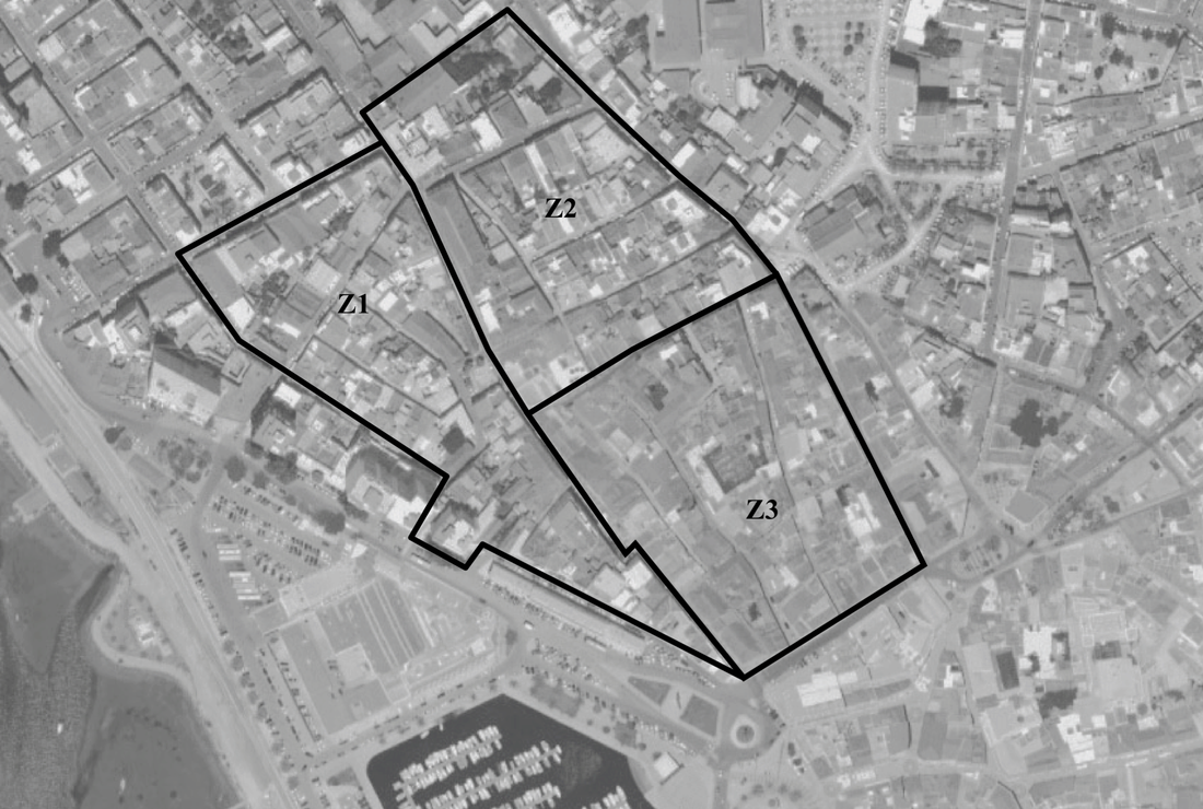
As part of this research project and commissioned by the Faro City Council, a complete identification and inspection survey of the old masonry buildings inserted in the Ribeirinha area of Faro was carried out. The data gathered from the inspection of 354 buildings, spread over 80,000 m2, were processed and then crosschecked with the corresponding case files existing at the local Department of Urban Regeneration, allowing a better knowledge of the existing structural typologies and their evolution throughout the years.
awareness, perception and communication of earthquake risk
Risks are associated to dangerous events that have an estimable probability of occurring and some potentially severe consequences. A risk is the potential to cause crisis, an emergency, a disaster and/or a catastrophe. The definition of risk acceptability is not technical but value driven. This definition is determined at two levels: at the individual level and at the state level. Every citizen decides what kind of risk he is willing to take in his daily life (examples: his choice of transportation, his choice to smoke or to drink alcohol, etc.). The government, on the other side, is setting risk acceptability limits on a societal level (example: speed limits, laws regulating construction areas and density, etc.). The historical experience of a society will affect the way that it view risks and crisis. This article deals with seismic risk perception and communication in Portugal. A survey carried out resourcing to a questionnaire was developed to assess the knowledge on seismic risk perception and awareness in the Algarve region. Two questionnaires were developed: i) General Public, ii) Professional and Technical (engineers, architects and decision makers). Results were treated statistically and thoroughly analysed and commented. Risk communication can influence communities to become aware of risks and it has a powerful influence on people's risk decision-making and behaviour. Risk communication has several objectives. It has the role to prevent risks, to reduce them and to make communities aware of the risks in order to develop their capacities, enhance communication and resilience to respond to crisis events.
Risks are associated to dangerous events that have an estimable probability of occurring and some potentially severe consequences. A risk is the potential to cause crisis, an emergency, a disaster and/or a catastrophe. The definition of risk acceptability is not technical but value driven. This definition is determined at two levels: at the individual level and at the state level. Every citizen decides what kind of risk he is willing to take in his daily life (examples: his choice of transportation, his choice to smoke or to drink alcohol, etc.). The government, on the other side, is setting risk acceptability limits on a societal level (example: speed limits, laws regulating construction areas and density, etc.). The historical experience of a society will affect the way that it view risks and crisis. This article deals with seismic risk perception and communication in Portugal. A survey carried out resourcing to a questionnaire was developed to assess the knowledge on seismic risk perception and awareness in the Algarve region. Two questionnaires were developed: i) General Public, ii) Professional and Technical (engineers, architects and decision makers). Results were treated statistically and thoroughly analysed and commented. Risk communication can influence communities to become aware of risks and it has a powerful influence on people's risk decision-making and behaviour. Risk communication has several objectives. It has the role to prevent risks, to reduce them and to make communities aware of the risks in order to develop their capacities, enhance communication and resilience to respond to crisis events.